KANSAS FISHING REPORTS: Region 1
Reports Updated 08/19/06
![]()
Click on the Map for a Region or Click on a Lake Name Below
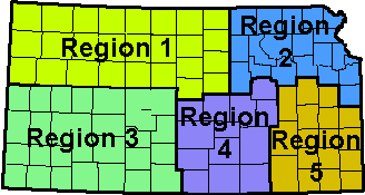
[ BACK ][ REGION 1 ] [ REGION 2 ] [ REGION 4 ] [ REGION 5 ]
| Click Here for KS Lake locator map |
When you're at the lake, stop in and check out the latest fishing
information from the bait shops that provide us with our reports. If you mention you saw their ad here, many offer discounts on bait or tackle. |
Add your own Fishing Report |
| Releases to support navigation also may lower levels of Milford and Tuttle Creek lakes by as much as two feet. Click Here for Full Story |
| CEDAR BLUFF | GLEN ELDER | KANOPOLIS | KIRWIN | LOVEWELL |
| SEBELIUS | WEBSTER | WILSON | ||
|
Updated 08/19/06 Lake Elevation at Normal Pool: 2144.0 Temperature: 84 Inflow: 2 cfs Outflow: 0 cfs Level: 14.16 feet low
Bluegill:
No Report Crappie: No Report Largemouth Bass: fair to slow using plastic baits White Bass excellent using jigs, spoons and white or chartreuse twister tails
Wiper fair using large spoons
The daily Creel Limit for Wipers is 2. GLEN
ELDER RESERVOIR Updated 08/19/06 Lake Elevation at Normal Pool: 1455.6 Temperature: Inflow: 3 cfs Outflow: 132 cfs Level: 7.08 feet low Largemouth Bass fair (18" length limit) Small mouth Bass fair using shad early morning or late afternoon Channel Catfish excellent on setlines at the west end of the lake using leeches, minnows and sunfish Crappie No Report Walleye good in Walnut Creek using jig/crawler and jig/leech combo (15" length limit) White Bass good lake wide using crank baits and rattletraps in Walnut Creek General Comments: New boating hazards have begun to cause problems north of the Mill Creek area where the old road bed and large flat are. They have added 5 new hazardous buoys indicating the south edge of the hazard area and anglers are advised to follow the river channel south of the buoys or travel through the hazard area with extreme caution. Updated 08/19/06 Lake Elevation at Normal Pool: 1463.0 Temperature: Inflow: 30 cfs Outflow: 50 cfs Level: 5.18 feet low Walleye/Saugeye slow to fair on the flats using slab spoons White bass fair on the windblown points using shad colored jigs, roadrunners, and buck tails. Wipers fair on the East side of Leota Cove using worms and sunfish Crappie poor Channel Catfish good using liver and liver on the south end of the dam Flatheads No Report General Comments: No boat ramps are useable. Updated 08/19/06 Lake Elevation at Normal Pool: 1729.3 Temperature: Inflow: 2 cfs Outflow: 0 cfs Level: 23.65 feet low Largemouth Bass No Report Channel Catfish fair using shad and shrimp on the bottom at the west end at Bow Creek and Cottonwood Grove Crappie fair using jigs and minnows around the North and South fish attractors Walleye poor White Bass No Report Wipers No Report Updated 08/19/06 Lake Elevation at Normal Pool: 1582.6 Temperature: Inflow: 0 cfs Outflow: 322 cfs Level: 2.74 feet low Largemouth Bass No Report Channel Catfish good to excellent using shad along the dam and around the outlet Crappie No Report Walleye fair using jigs and minnows at night (18" length limit) White Bass/Wipers good while trolling using crank baits SEBELIUS
RESERVOIR Updated 08/19/06 Lake Elevation at Normal Pool: 2304.3 Temperature: Inflow: 1 cfs Outflow: 1 cfs Level: 17.62 feet low The 15" length limit for Largemouth Bass has been lifted. Largemouth Bass No Report Carp No Report Bluegill No Report Channel Catfish fair using shad and worms off the bottom Crappie fair using jigs and minnows around the Public Fishing Dock and the Marina Dock Saugeye/Walleye fair Wipers fair using worms at the north end of the dam Updated 08/19/06 Lake Elevation at Normal Pool:1892.5 Temperature: Inflow: 1 cfs Outflow: 0 cfs Level: 28.05 feet low Wipers/White Bass fair Crappie poor using jigs and minnows around the North and South fish attractors Channel Catfish good using worms, minnows, shad and chicken liver on the bottom Flathead No Report Largemouth Bass No Report Rainbow trout good Small mouth Bass No Report Walleye poor General Comments: The fish feeder in the Stilling Basin is now up and running and feeds 7am and 8pm. The fish feeder by the breakwater is up and running also and feeds every three hours starting at 6:00 am Updated 08/19/06 Lake Elevation at Normal Pool: 1516.0 Temperature: Inflow: 5 cfs Outflow: 15 cfs Level: 6.47 feet low
Channel Catfish fair worms and liver on the bottom Crappie poor using jigs and minnows around the brush piles Stripers fair using live bait on the road beds and in the channel breaks Walleye fair using jig/night crawler at the west end of the dam and 40 feet deep White Bass fair using white jigs along the banks Black Bass fair to good using crawdads, crank baits and top water lures Boat Ramps: The Elm Creek ramp is usable, only the east boat ramp in Minooka have head of long lines about and hour wait on the weekends. Hell Creek ramp is good for all 3 lanes, the Otoe ramps is good for one lane and fair on the other, the Spillway boat ramp one lane only and the Lucas COE ramps are good on all lanes. |
This page was last updated: 01/14/14
[ BACK ][ REGION 1 ] [ REGION 2 ] [ REGION 4 ] [ REGION 5 ]