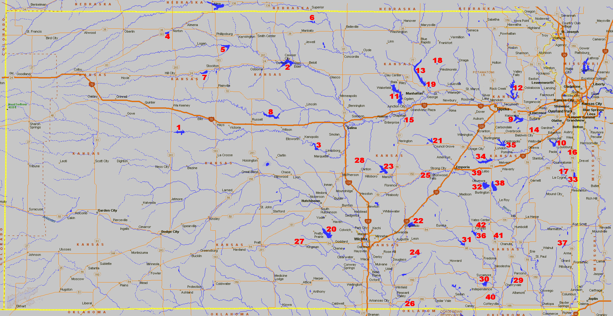
Kansas Lake Locator Map The Lakes are listed below, just pick out the lake you want and correspond it with the number on the map. They are also listed in their regions with a region map to show you their general area. |
|||||
This map shows the different regions.
|
This map shows the different regions.
|
||||||
| REGION 1 Reservoirs |
REGION 4 Reservoirs |
||||||
| Number | Lake Name | Acreage | Location | Number | Lake Name | Acreage | Location |
| 1. | Cedar Bluff | 6,000 | 13 miles South of I-70 fromOgallah Interchange on K-147 |
20. | Cheney | 9,550 | 20 Miles West of Wichita |
| 2. | Glen Elder (Waconda) |
12,586 | 12 miles West of Beloit on US-24 | 21. | Council Grove | 3,280 | 1 Mile North of Council Grove on K-57/177 |
| 3. | Kanopolis | 3,550 | 33 miles Southwest of Salina on K-149 and K-141 |
22. | El Dorado | 8,000 | 3 Miles East & 2 Miles North of El Dorado |
| 4. | Keith Sebelius (Norton) |
2,300 | 3 miles Southwest of Norton off US-24 |
23. | Marion | 6,160 | 4 Miles Northwest of Marion off US-56 |
| 5. | Kirwin | 5,000 | 15 miles Southeast of Phillipsburg on K-9 | State Fishing Lakes | |||
| 6. | Lovewell | 2,986 | 4 miles East & 10 miles North of Mankato on US-14 |
24. | Butler | 124 | 3 Miles West & 1 Mile North of Latham |
| 7. | Webster | 3,780 | 8 miles West of Stockton off US-24 | 25. | Chase | 109 | 2 1/2 Miles West of Cottonwood |
| 8. | Wilson | 9,040 | 8 miles North on K-232 from I-70 Wilson exit |
26. | Cowley | 84 | 13 Miles East of Arkansas City on US-166 |
| Region 2 Reservoirs |
27. | Kingman | 144 | 7 Miles West of Kingman | |||
| Number | Lake Name | Acreage | Location | 28. | McPherson | 46 | 6 Miles North & 2 1/2 Miles West of Canton |
| 9. | Clinton | 7,000 | 5 miles West of Lawrence on K-10 | REGION 5 Reservoirs |
|||
| 10. | Hillsdale | 4,580 | 3 Miles Northwest of Paola | Number | Lake Name | Acreage | Location |
| 11. | Milford | 16,020 | 5 Miles Northwest of Junction City on US-77 |
29. | Big Hill | 1,240 | 4 1/2 Miles East of Cherryvale |
| 12. | Perry | 12,000 | 18 Miles Northeast of Topeka on US-24 | 30. | Elk City | 4,450 | 4 Miles Northwest of Independence |
| 13. | Tuttle Creek | 15,800 | 6 Miles North of Manhattan on K-13 | 31. | Fall River | 2,500 | 25 Miles South of Eureka off K-96 |
| State Fishing Lakes | 32. | John Redmond | 9,400 | 2 Miles North & 1/2 Mile West of Burlington on US-75 |
|||
| 14. | Douglas | 180 | 1 1/2 Miles North & 1 Mile East of Baldwin | 33. | La Cygne | 2,600 | 5 Miles East of LaCygne |
| 15. | Geary | 97 | 8 1/2 Miles South & 2 Miles West of Junction City |
34. | Melvern | 7,000 | 35 Miles South of Topeka on US-75 |
| 16. | Louisburg Middle Creek |
280 | 7 Miles South of Louisburg | 35. | Pomona | 4,000 | 25 Miles South of Topeka on US-75 |
| 17. | Miami | 118 | 8 Miles East & 5 Miles South of Osawatomie | 36. | Toronto | 2,800 | 15 Miles Southwest of Yates Center off US-54 |
| 18. | Pottawatomie 1 | 24 | 5 Miles North of Westmoreland | State Fishing Lakes and Other Waters | |||
| 19. | Pottawatomie 2 | 75 | 1 1/2 Miles East & 2 1/2 Miles North of Manhattan |
37. | Bone Creek | 4 Miles North & 3 Miles East of Arma | |
| 38. | Coffey County Lake | ||||||
| 39. | Lebo City Lake | ||||||
| 40. | Montergomery | 105 | 3 Miles South & 1 Mile East of Independence |
||||
| 41. | Wilson | 110 | 1 Mile East of Buffalo | ||||
| 42. | Woodson | 180 | 5 1/2 Miles East of Toronto | ||||
